Met Office data portal helps academia access climate data

Allows users to better understand and respond to climate change
The Met Office’s Climate Data Portal has recently gone live, giving academic organisations improved access to climate data and other resources, allowing them to better understand and respond to climate change. Part of the Met Office’s wider strategy to maximise the benefits of its data, the portal contains 60 different data layers, as well as guidance and information.
Built using geospatial technology from Esri UK, the portal makes it easier for businesses, government or academia to combine open climate data with their own data and reveal the future impact of extreme conditions on their operations, including heatwaves, floods or droughts.
Combining Met Office expertise and authoritative data with Esri’s geospatial tools, the portal presents complex scientific climate projections in easy-to-use formats, ready to visualise and analyse in GIS and non-spatial applications or integrate into business processes for improved decision making. Spatial analysis can be performed at a global, regional or local level enabling location-specific action plans to be developed.
“Historically, climate science has defined the problem, now it’s moving to help with the solution, providing information at a local level which is highly relevant to UK organisations,” explained Professor Jason Lowe, Head of Climate Services at the Met Office. “By combining the Met Office’s latest projections with Esri UK’s geospatial tools, the reach and value of this data is greatly extended. UK stakeholders can investigate their physical climate risks over the next 50 to 100 years. The most detailed climate projections reveal a greater chance of warmer, wetter winters and hotter, drier summers and these help users plan and prepare for extreme weather, climate change and the reporting which new regulations, linked to climate change, will require.”
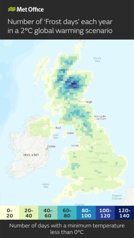
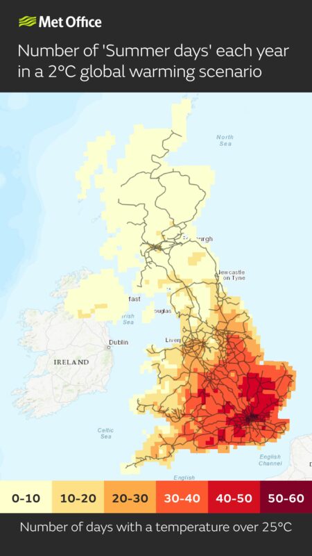
Data on temperature extremes can be used to understand the impacts on transport infrastructure, health and energy demand. For example:
- Days above 25°C can indicate when trains could be disrupted due to overheating of railway infrastructure
- Nights above 20°C can indicate heat stress as night time temperatures impact the body’s ability to recover from higher daytime temperatures
- Days below 0°C can indicate transport disruption and increased energy demand for heating
The portal will also help provide insight to help organisations start their response to regulatory climate reporting such as TCFD (Task Force on Climate-related Financial Disclosures), which is being rolled out across the UK.
During a pilot phase of the portal, which saw almost 4,000 users access the data, early users included the RSPB (Royal Society for the Protection of Birds) and Forestry and Land Scotland, the organisation responsible for managing Scotland’s national forest estate, owned by the Scottish government. Some of the most popular data during this phase included projections of summer days (where temperature reaches over 25°C) for different global warming scenarios.
Emma Teuten, Lead GIS Analyst at RSPB Scotland, said:
“The portal makes working with climate data faster and more accurate and saves months of development time when trying to understand the impact of climate change on specific sites in Scotland. We already use Esri’s GIS extensively and the new Met Office portal eliminates the time-consuming data conversion previously required, as the data is now in ready-to-use geospatial formats.”
Alan Gale, Adaption and Resilience Manager, Forestry and Land Scotland, commented: “Organisations like ours rely on authoritative and easy to access information for climate change decision making, in land planning and management. The innovative approach being taken by the Met Office portal makes important climate data available to a broader range of users and critically, lets us understand the local and regional climate differences at a glance. Predicting future climate is particularly important in forestry, given the long time scales involved – trees we plant today will still be growing in the 2050s and 2080s, for example.”
“The Climate Data Portal is a giant step forward in making climate data more usable for UK stakeholders,” commented Pete Wilkinson, Managing Director of Esri UK. “Climate change presents a major challenge and this challenge is a geographic one. Using geospatial technology as a delivery mechanism for climate data makes it quickly accessible and usable in spatial and temporal analysis, helping to identify at-risk areas and develop location-specific action plans.”
Responses